


ORANGEVILLE, Orange County, Indiana
About
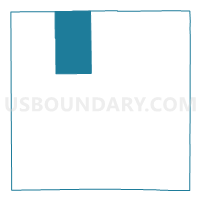
Outline

Summary
| Unique Area Identifier | 579958 |
| Name | ORANGEVILLE |
| County | Orange County |
| State | Indiana |
| Area (square miles) | 28.11 |
| Land Area (square miles) | 28.01 |
| Water Area (square miles) | 0.10 |
| % of Land Area | 99.65 |
| % of Water Area | 0.35 |
| Latitude of the Internal Point | 38.63856290 |
| Longtitude of the Internal Point | -86.54477510 |
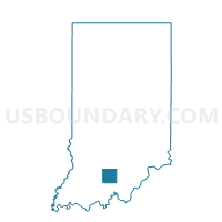
Maps

Graphs
Select a template below for downloading or customizing gragh for ORANGEVILLE, Orange County, Indiana


Neighbors
Neighoring Voting District (by Name) Neighboring Voting District on the Map
- FLE WEST BADEN, Orange County, IN
- MARION 05C, Lawrence County, IN
- NORTHWEST, Orange County, IN
- ORLEANS NORTHWEST, Orange County, IN
- ORLEANS SOUTHWEST, Orange County, IN
- PAOLI NORTHWEST, Orange County, IN
- SPICE VALLEY SOUTH, Lawrence County, IN
Top 10 Neighboring County Subdivision (by Population) Neighboring County Subdivision on the Map
- Marion township, Lawrence County, IN (9,449)
- Paoli township, Orange County, IN (6,031)
- French Lick township, Orange County, IN (4,699)
- Orleans township, Orange County, IN (3,555)
- Spice Valley township, Lawrence County, IN (2,423)
- Orangeville township, Orange County, IN (658)
- Northwest township, Orange County, IN (375)
Top 10 Neighboring Unified School District (by Population) Neighboring Unified School District on the Map
- Mitchell Community Schools, IN (12,009)
- Paoli Community School Corporation, IN (9,318)
- Springs Valley Community School Corporation, IN (5,760)
- Orleans Community Schools, IN (4,762)